A Pacific Coast Highway road trip from San Francisco to Los Angeles covers roughly 450 to 500 miles of California coastline, depending on the detours you take. The drive itself could be done in two long days, but a week gives you time to stop: for sea lions in Monterey, the cliffs and redwoods of Big Sur, elephant seals at San Simeon, and the beach towns between Santa Barbara and Malibu. This itinerary lays out a 7-day route, with the best time to go and the practical things worth knowing before you set off.
Before you go: road conditions in Big Sur
Landslides regularly close sections of Highway 1 through Big Sur, sometimes for months at a time. Before you plan the route, check the current status on Caltrans QuickMap or the Caltrans District 5 updates. If part of the road is closed, you can usually still reach Big Sur from one end and loop back via Highway 101, which runs inland and parallel to the coast.
North to south or south to north?
Drive north to south, from San Francisco to Los Angeles. You’ll be in the lane closest to the ocean, which makes it easier and safer to pull into the viewpoints, and the views open up ahead of you instead of behind.
7-day Pacific Coast Highway itinerary
Day 1: San Francisco to Santa Cruz
Leave the city on Highway 1 through Pacifica and down the San Mateo coast. Stop at Half Moon Bay for lunch and at Pigeon Point Lighthouse, one of the tallest lighthouses on the West Coast. In Santa Cruz, walk the wharf, ride the wooden Giant Dipper roller coaster at the Beach Boardwalk, and watch the surfers at Steamer Lane. If you have time, the redwoods at Henry Cowell Redwoods State Park are only a short drive inland.
Day 2: Monterey and Carmel
Spend the morning at the Monterey Bay Aquarium, one of the best in the country, then walk along Cannery Row and the coastal path to spot sea otters and sea lions. Drive the 17-Mile Drive through Pebble Beach for its rocky coves and the Lone Cypress, then finish in Carmel-by-the-Sea, a small town of storybook cottages, galleries and a white-sand beach. Stay the night in Carmel or Monterey, because Big Sur has few rooms and they book up early.
Day 3: Big Sur
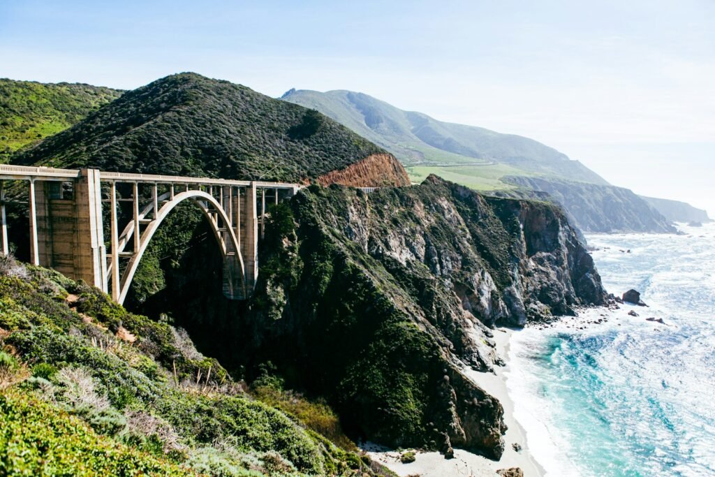
This is the heart of the trip, so start early and take the whole day. Just south of Carmel, Point Lobos State Natural Reserve has short trails along some of the most beautiful coastline in California. Then cross Bixby Creek Bridge, the classic Big Sur photo stop, and continue to Pfeiffer Big Sur State Park for a walk among the redwoods. At Julia Pfeiffer Burns State Park, a short path leads to the viewpoint over McWay Falls, which drops onto a small beach below the cliffs. Fill up on gas before you leave Carmel, as there are few stations in Big Sur and prices are high, and expect little or no phone signal for long stretches.
Day 4: San Simeon, Cambria and Morro Bay
South of Big Sur, the road flattens out toward San Simeon. Tour Hearst Castle, the hilltop mansion built for newspaper owner William Randolph Hearst (book tickets in advance). A few miles north, the Piedras Blancas elephant seal rookery has a free viewing area, and seals are on the beach in every season, with the biggest numbers in winter during breeding. Spend the evening in the small town of Cambria or at Morro Bay, whose huge volcanic plug, Morro Rock, sits at the edge of the harbor.
Day 5: San Luis Obispo and Pismo Beach to Santa Barbara
Stop in San Luis Obispo for its relaxed downtown and the Mission San Luis Obispo de Tolosa, then continue to Pismo Beach for the pier and wide sandy beach. From there it’s a couple of hours to Santa Barbara. If you like wine, detour inland through the Santa Ynez Valley and the Danish-style town of Solvang on the way.
Day 6: Santa Barbara
Santa Barbara deserves a full day. Visit the Old Mission Santa Barbara, walk State Street and the Funk Zone, go up the clock tower of the County Courthouse for views over the red-tiled roofs, and end the day on Stearns Wharf or at East Beach. The city is a good place to slow down before the traffic of Los Angeles.
Day 7: Malibu to Los Angeles
Drive through Ventura and along the coast into Malibu. El Matador State Beach has sea stacks and caves that are worth the steep path down, and Point Dume offers a clifftop walk with wide views. Finish at Santa Monica Pier, where a sign marks the end of Route 66, and watch the sunset over the Pacific.
Best time for a Pacific Coast Highway road trip
September and October are often the best months. Summer fog has usually cleared, the weather is warm and the summer crowds have gone. Spring, from April to May, is also lovely, with green hills and wildflowers in Big Sur.
Summer is the busiest season, and the coast is often covered in thick morning fog, especially in June, which locals call “June Gloom”. It usually burns off by the afternoon, but it can hide the views in Big Sur. Winter is quiet and cheap, and it’s the best time for elephant seals and gray whale migration, but storms bring the highest risk of rain and road closures.
Practical tips
- Book Big Sur, Carmel and Santa Barbara accommodation early, especially for weekends between May and October.
- Download offline maps before Big Sur, where signal is patchy.
- Many popular stops charge for parking, and lots at Bixby Bridge and McWay Falls fill quickly. Arrive early in the day.
- Bring layers. Even in summer, the coast can be cool and windy while inland towns are hot.
- If you’re renting a car one-way from San Francisco to Los Angeles, expect a drop-off fee and compare a few companies.
For more ideas in California, see our guide to the best hostels in San Diego, or plan the route day by day with our AI trip planner. Traveling with children? Our road trip with kids guide covers the practical side.
Frequently asked questions
How many days do you need for the Pacific Coast Highway?
Plan on at least five days from San Francisco to Los Angeles, and seven to ten if you want time to hike in Big Sur and spend a full day in Santa Barbara.
What is the most scenic part of the Pacific Coast Highway?
Big Sur, the roughly 90-mile stretch between Carmel and San Simeon, is the most dramatic section, with the road cut into cliffs high above the ocean.
Is the Pacific Coast Highway open?
Sections through Big Sur close from time to time because of landslides and storm damage. Check Caltrans QuickMap for current conditions shortly before your trip.
Is the Pacific Coast Highway hard to drive?
It isn’t difficult, but the Big Sur section is narrow and winding with steep drops and few guardrails in places. Take your time, use the turnouts to let faster traffic pass, and avoid driving it after dark.